FOOTPATHS

Footpath Officer - Chris Alliston
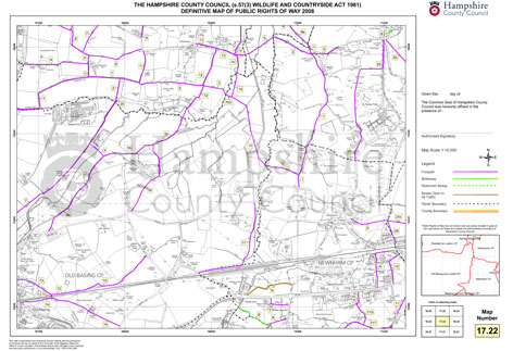
There are numerous footpaths within the Civil Parish and surrounding area. All are clearly shown on the Ordnance Survey 1:25,000 Explorer number 144.
Footpath 1
...runs approximately north along a gated track way starting about 600 metres from the speed limit sign on Newnham Lane; it crosses the Tylney Park golf course, in Rotherwick Parish, and then forks right up Stroud Green Lane into Rotherwick village, or forks left past (the evocatively named) Summerstead Farm and on to Hartley Wespall or Sherfield-on-Loddon
Footpath 17
...goes eastward from Blackstocks Lane by the bridge over the M3 and keeps rather noisily by the motorway for 500 metres before turning into Hang Wood, about 450 metres later the path splits: by going north along F.P.5 one reaches the A30 alongside the Baredown, or by continuing easterly along F.P.17 one reaches Heather Row. On Heather Row it is possible to turn right (south) and cross the M3 on a footbridge going thence into Butter Wood or on to Eastrop. Otherwise one turns left (north) to reach Hook Common
Footpath 2
...takes off from F.P. 1 about 150 metres from Newnham Lane and goes west down to a footbridge over the River Lyde (Anglo-Saxon for a ‘torrent’) and thence past Wildmoor (now tamer than it used to be, but nevertheless remote) and connects with paths to Old Basing and Sherfield
Footpath 3
Church Path... leads between Naishes Farm House and Tithe Barn (both on Newnham Green. Note the old ridged area leading back across the Green to the Church - which is the beginnings of the pathway - designed to make church going drier for Hook people. From Tithe Barn leads over the fields to a planked walkway crossing Newnham Brook (The Strings), thence along an ancient hedgerow to reach Hook. It passes Owens Farm and the Bowling Club and so to Jubilee Green and the War Memorial on the A30, whence a left turn along Great Sheldons Coppice can take one past Sherlands Copse and on to Rotherwick
Footpath 6
Green Lane starts from Crown Lane about 150 metres from the A30 and leads westerly to the Red Lion pub on the Lyde at Water End. There it can connect with F.P. 8 (q.v.) by walking for 200 metres along Andwell Lane almost opposite the pu
Footpath 8
...‘Coop Lane’ connects Andwell Lane to Blackstocks Lane near the road bridge over the M3. Coop Lane and Green Lane are the only bridle paths in the Civil Parish